Chaco Culture National Historic Park
More than a thousand years ago, the Ancestral Puebloans constructed a number of larges pueblos in Chaco Canyon, New Mexico. The ruins of these ancient pueblos came to the attention of the Americans shortly after the United States and Mexico signed the Treaty of Guadalupe in 1848 which gave the United States governmental jurisdiction over much of what is now the Southwest. While the United States claimed that it was acquiring this territory in order to bring peace and stability to the region, the intrusion of the Americans into the region actually increased the cycles of violence with the Navajo. In 1849, Lieutenant Colonel John M. Washington led a putative expedition against the Navajo. On a detached reconnaissance, topographical engineer Lieutenant James H. Simpson entered Chaco Canyon and located ten ancient Ancestral Puebloan pueblos.

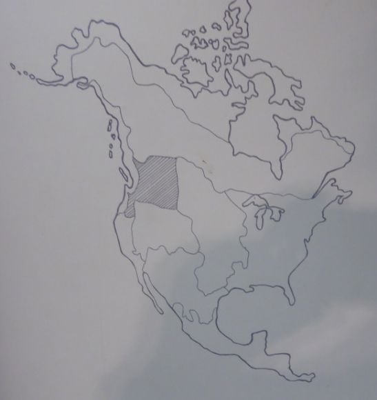
The map of the Chaco Culture National Historical Park is shown above.
The Initial Discovery:
As Lieutenant Simpson led his reconnaissance expedition through Chaco Canyon, he noted the characteristics of the pueblos and, with the help of his Navajo and Mexican guides, he gave them names. Lieutenant Simpson was actually the first to designate the canyon as “Chaco” which appears to be from the Spanish transliteration of the Navajo name for Chacra Mesa which was Tzak aih meaning “white string of rocks.”
Pueblo Pintado (Spanish for “painted village) was named by their Mexican guide Carravahal. Others in the party suggested naming it Montezuma’s Pueblo, Red Pueblo, Great Pueblo, and Pueblo of the Rats. Lieutenant Simpson counted 54 “apartments” on the ground floor and estimated that it must have originally been three stories high. Archaeologists would later find that the L-shaped pueblo had 135 rooms, 19 kivas ceremonial underground structures), and 1 great kiva.


The name Montezuma’s Pueblo reflected the idea that these large structures must have somehow been built by the Aztecs under the leadership of Montezuma. The mistaken idea that Aztecs under Montezuma built many of the ancient villages in the southwest continues to persist, even though the archaeological findings show that these villages were built long before Montezuma.
Wijiiji (named Weje-gi by Carravahal which means “Greasewood House” from the Navajo word for the greasewood plant) which measured nearly 700 feet in circumference.


Wijiiji is shown above.
Pueblo Una Vida (Spanish for “One Life”) measured 994 feet in circumference. Archaeologists would later determine that the pueblo had about 160 rooms and that construction began sometime in the 800s. The pueblo also has four kivas and two great kivas.

Una Vida is shown above.
Hungo Pavi (the meaning of this name is unknown) measured 872 feet in circumference.

Hungo Pavi is shown above.
Chetro Ketl, a name which Carravahal said means Rain Pueblo. The pueblo measured 1,300 feet in circumference and Lieutenant Simpson felt that it was once four stories high.

The large kiva at Chetro Ketl is shown above.
Pueblo Bonito (Spanish for “Beautiful Village”) which was 1,300 feet in circumference and was once four stories high. Archaeologists would later determine that this pueblo was inhabited from the 850s through the early twelfth century. Over a million sandstone blocks were carved for its construction.


Pueblo Bonito is shown above.
Pueblo Bonito has over 350 ground rooms, 32 kivas, and 3 great kivas.
Pueblo del Arroyo (Spanish for “Village by the Wash”) which Lieutenant Simpson estimated at 1,000 feet in circumference. It differs from the other great houses in Chaco Canyon in that it was not built near the northern cliff face and is oriented to the east rather than to the south. The building was originally four stories high and had 125 ground floor rooms and 17 kivas. Archaeologists would later determine that initial construction began about 1060.
Pueblo de Peñasco Blanco (Spanish for “Rocky White”) which was 1,700 feet in circumference. According to Lieutenant Simpson:
“there is a regular alternation of large and small stones, the effect of which is both unique and beautiful.”
This is the westernmost great house in Chaco Canyon. Archaeologists would later identify irrigation canals and a system of fields associated with this site. The oval ground plan is unlike the D-shape of many of the other great houses in the canyon. Peñasco Blanco has four great kivas. Construction of this pueblo began in the early tenth century.


Peñasco Blanco is shown above.
Vandalism:
The ruins in Chaco Canyon were seen by some non-Indians was a resource would could be mined for ancient artifacts which could be sold to collectors. In 1877, the Geological and Geographical Survey of the Territories noted that holes had been poked through the exterior walls of Pueblo Bonito in Chaco Canyon by vandals searching for artifacts.
Hyde Exploring Expedition:
The next major American group to explore Chaco Canyon came in 1896. At this time the Hyde Exploring Expedition began what would be four summers of archaeological excavations at the ruins. The Expedition was under the auspices of Frederick Putnam of the American Museum of Natural History. Rancher-turned-archaeologist Richard Wetherill and George Pepper, a student with no experience outside of the classroom, led the expedition. A number of Navajo men were hired to do the digging.
During the next four seasons, the Hyde Exploring Expedition excavated 190 rooms at Pueblo Bonito and sent thousands of artifacts to the American Museum of Natural History. At the end of their first season, they shipped an entire freight car filled with artifacts back to New York.
Edger Hewett, the president of New Mexico Normal University, became concerned that the artifacts from Chaco Canyon were being transferred to New York. He accused the Hyde Exploring Expedition of selling artifacts and vandalizing the Chaco sites. While the charges were found to have no merit, the Department of the Interior ordered the Hyde Exploring Expedition to stop excavations in 1901.
National Geographic Society:
In 1921, the National Geographic Society sponsored an archaeological excavation at Chaco Canyon under the leadership of Neil M. Judd. According to the National Geographic announcement of the expedition:
“This expedition hopes to discover the historic secrets of a region which was one of the most densely populated areas in North America before Columbus came, a region where prehistoric peoples lived in vast communal dwellings whose ruins are ranked second to none of ancient times in point of architecture.”
The National Geographic Society directed Judd to completely excavate a promising great house in Chaco Canyon. Judd and his team selected Pueblo Bonito and spent three years excavating the pueblo. Judd published his research in 1927.
University of New Mexico:
From 1935 through 1970 the University of New Mexico excavated at Chaco Canyon. The work was directed by Edger Hewett and focused primarily on education students in archaeology. Very little of this work has ever been published.
Chaco Canyon National Monument:
In 1907 Congress created the Chaco Canyon National Monument to preserve the numerous Ancestral Puebloan (“Anasazi”) ruins in the area. In 1980 the National Monument was re-designated as the Chaco Culture National Historical Park. At this time an additional 13,000 acres was added to the park. It was declared a World Heritage Site in 1987.
Related Posts
-
 Ancient America: The Birth and Death of a Pueblo
In 1245 CE, the Anasazi (Ancestral Puebloan) began construction on …
Ancient America: The Birth and Death of a Pueblo
In 1245 CE, the Anasazi (Ancestral Puebloan) began construction on … -
 Carved Stone Figures in the Plateau (Photo Diary)
The Maryhill Museum located near Goldendale, Washington, has a display …
Carved Stone Figures in the Plateau (Photo Diary)
The Maryhill Museum located near Goldendale, Washington, has a display … -
 Aztec and Other Mexican Artifacts (Photo Diary)
In major museums, only a small fraction of the artifacts …
Aztec and Other Mexican Artifacts (Photo Diary)
In major museums, only a small fraction of the artifacts … -
 Veracruz
 is a region in Mexico’s gulf coastal lowlands. This …
Veracruz
Veracruz is a region in Mexico’s gulf coastal lowlands. This …